
Map of the Month
These maps tell us we need to cool our sweltering streets


Walkable cities are gaining traction. Our Map of the Month shows which Melbourne suburbs are walking distance to childcare, pharmacies and GPs


Published 31 May 2024
Choosing where to live is a complex decision. You need to balance finding somewhere that’s affordable, is suitable for your housing needs, is a convenient location and has nearby services and amenities.
But what services and amenities do you need, and how close do they need to be?
Our Map of the Month shows the percentage of each Melbourne suburb that is within a 20-minute walk of a childcare centre, pharmacy or GP. Click on the buttons above the map to switch between the three maps.
Twenty-minute neighbourhoods feature in many Australian planning strategies like the Victorian government’s Plan Melbourne 2017-2050.
The 20-minute neighbourhood grew from the concept of the 15-minute city. This is a city that promotes higher density, mixed-use development and emphasises active transport (like walking or bike riding) to reach work, shopping, education and entertainment.
Map of the Month
These maps tell us we need to cool our sweltering streets
This concept gained popularity during COVID-19, with many global cities – like Barcelona, Paris, Milan and Madrid – publishing plans to encourage the types of urban development needed for 15-minutes cities.
For example, Barcelona has been building ‘superblocks’ where they ban or restrict cars to create zones of increased public space conducive to walking and cycling.
This has brought with it considerable health and economic benefits.
Imagine you lived somewhere where almost everything you need in your day-to-day life is 20 minutes away. If you needed to see a doctor, shop for groceries, visit greenspace or a park, or go to work – it is all just a 20-minute walk or bike ride away.
The Victorian plan for a 20-minute neighbourhood has six hallmarks:
Safe, accessible, and well-connected
Supportive of local economies
Provide convenient access to services
Are climate resilient
Provide high quality public spaces
Housing density that make a 20-minute neighbourhood viable
But a 20-minute neighbourhood isn’t one-size-fits-all. Different people at different stages in their lives will consider some features essential to their needs, and others may be superfluous.
A retiree might rank access to GPs or community centres high, while a young family will put more value on access to nearby childcare and schools.
Melbourne is often ranked one of the world’s most liveable cities (number three in 2023), with Melbourne’s inner north recognised as having the coolest street in the world.

Politics & Society
‘Bumping spaces’ build community – when they are within reach
But Greater Melbourne is a large and diverse city, with huge variations between its higher density inner-city neighbourhoods and its much lower density suburbs and peri-urban regions.
For our Map of the Month, we looked at access to various services across Melbourne – specifically childcare centres, primary health GPs and pharmacies – to determine how many neighbourhoods are truly 20-minute.
This work is based on a project we are completing for the ARC Centre of Excellence for Children and Families over the Life Course to map spatial disadvantage when it comes to access to services across Melbourne and Perth.
To accomplish this, we conducted a ‘shortest path’ analysis from every intersection in Greater Melbourne (about 500,000 points) to count the number of these services that can be reached within a 20-minute walk (or 1,600 metres).
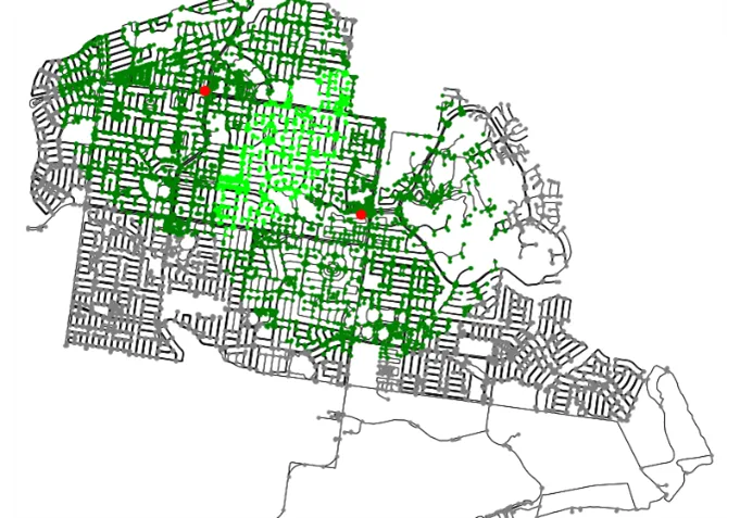
Using this data, we created an index of accessibility to childcare, GPs and pharmacies for each suburb across Greater Melbourne (see our Map of the Month at the top of this story).
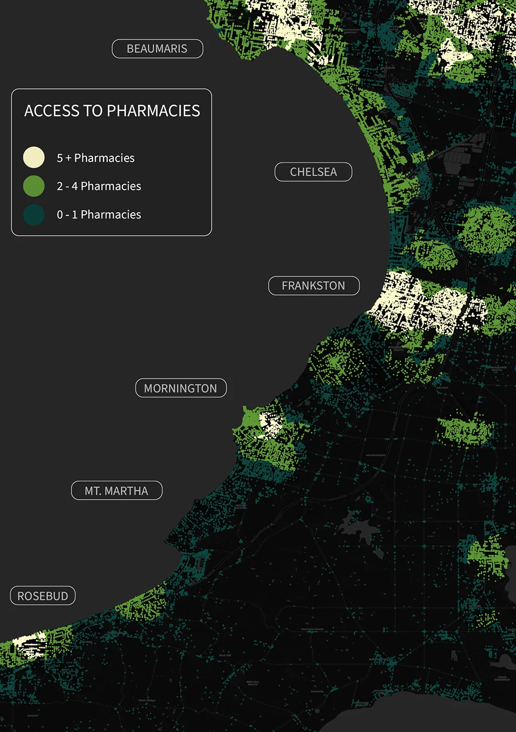
Most inner and middle suburbs in Melbourne seem to have broad access to these services within 20 minutes. However, access drops off towards the fringes, with peri-urban areas having low to no 20-minute access to these services.
Childcare seems more evenly distributed across the city than GPs and pharmacies.
When we look in more detail at certain areas, and include the number of each service available within a 20 minute walk, we can see that many of the inner and mid-city gaps are in areas with large parks, green space, creek corridors and green wedges around the edges of the city.
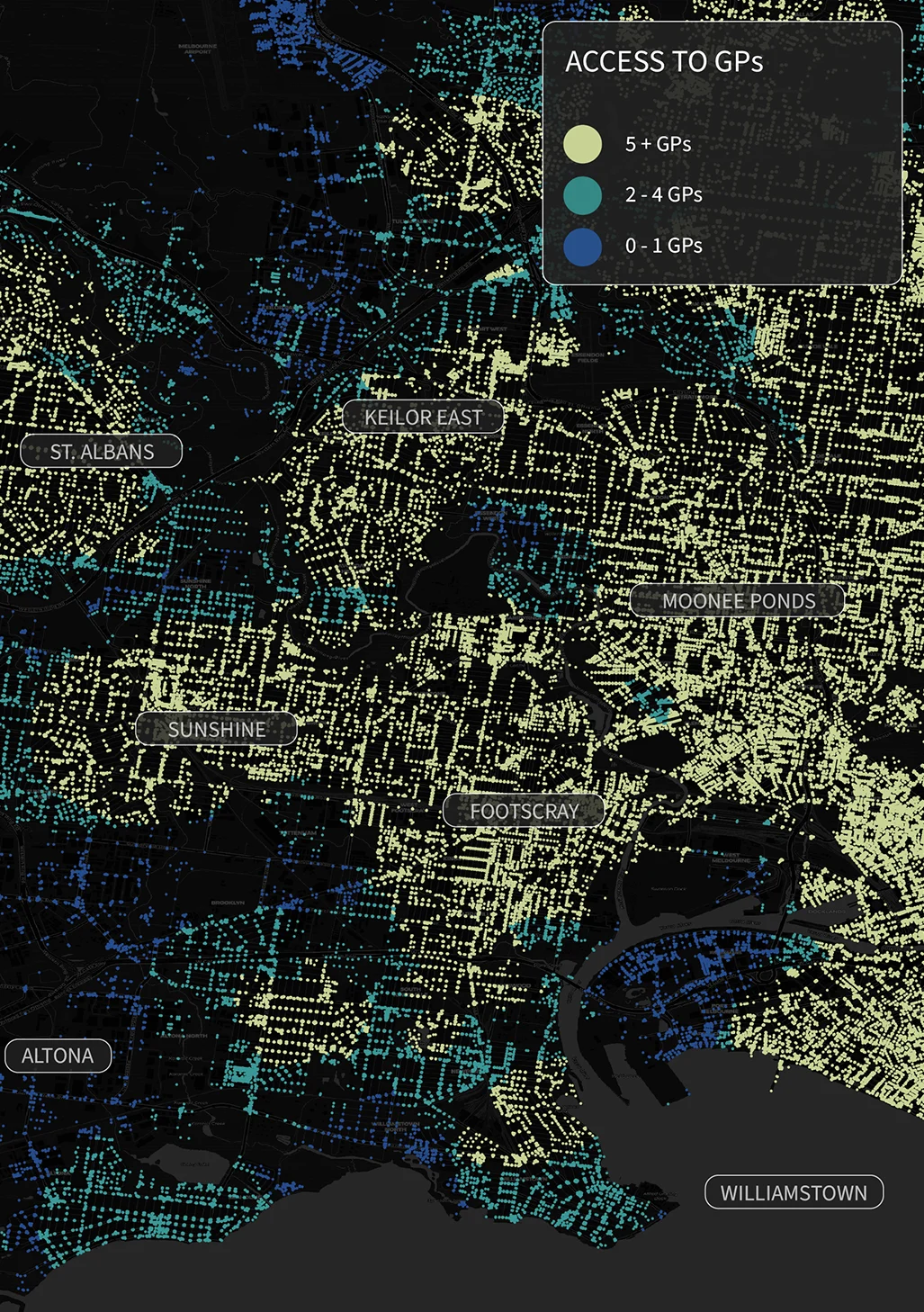
At this level of detail, there are some notable gaps in suburbs along the Frankston train line, in the predominately industrial areas of Port Melbourne and Altona, and towards the high-growth areas in western Melbourne.
Suburbs like Frankston and Mornington show small pockets of high availability surrounded by large areas of low to no access.
The corridor from Altona through Newport to Port Melbourne varies greatly, with some large gaps in coverage.
The implications of this are clear. Some areas are well serviced while neighbouring areas miss out. Areas like Fishermans Bend are planned to support large increases in residential populations, but currently there are very few services available to provide new residents a 20-minute neighbourhood.
This risks building car-dependency in these areas.
We should note that our analysis only measured the presence of a service but not its capacity – like whether a childcare facility can accommodate the local demand.
Our research continues to explore what needs to be done to ensure that our 20-minute neighbourhoods not only have the services that are needed, but that there is a match between the number of local residents who need to use them and the capacity of these childcare facilities, pharmacies and GPs to provide them.
There are also many other elements of 20-minute neighbourhoods that need to be examined: access to art and culture, nearby public transportation, provisions for active transport and the list goes on.
But of course, none of this is any use to most residents without suitable affordable housing in these areas.
Map of the Month is a science communication project of the University of Melbourne (Melbourne Centre for Cities, AURIN, Melbourne Data Analytics Platform and Pursuit) using maps to spark important policy conversations across metropolitan Melbourne. This pilot is supported by the Lord Mayor’s Charitable Foundation and in partnership with the Victorian Office for Suburban Development and the Municipal Association of Victoria. Academics, community leaders and government representatives from across Melbourne contribute to the maps and accompanying stories.
This month’s story was produced with support from the the ARC Centre of Excellence for Children and Families over the Life Course, and the map was produced by Dr Sachith Seneviratne, Flavia Barar and Dr Emily Fitzgerald. Childcare data is from ACECQA and pharmacy and GP locations from the National Health Directory.