Sciences & Technology
Clock on: When weather gets into a routine


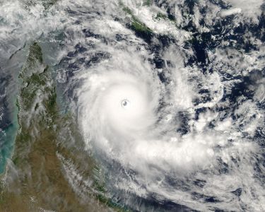
As Hurricane Irma wreaks a path of devastation across the Caribbean, just why do these meteorological monsters form in the first place and are they the result of climate change?
Published 8 September 2017
Imagine you’re swimming in the ocean, and the water temperature at the surface is 27°Celsius. It’s not quite 40-degree bath time bliss, but still twice as warm as you’d encounter during a mid-winter dip in Port Phillip Bay. How relaxing – unless you knew you were wallowing in the perfect foundation for a hurricane.
Professor Ian Simmonds, from the School of Earth Sciences at the University of Melbourne, describes hurricanes as being “vertically organised”. That lovely warm water is the base ingredient in a column-shaped cocktail that can wreak the sort of devastation caused by Hurricane Irma, and seen barely a week earlier when Hurricane Harvey made landfall in southern Texas.

The science behind these natural disasters – called typhoons in the Pacific, hurricanes in the Atlantic and cyclones in our part of the world – reads like ticking off a sinister shopping list.
First, there must be a sufficient supply of moisture to get the hurricane going, which is why they form over the ocean at hotter times of the year. Crucially, the winds near the surface must be similar to the winds several kilometres above – there can’t be too much “wind shear”, or variation in horizontal force, otherwise the top of the “chimney stack” will be blown over.
“Once you’ve got those things ready, basically any small trigger – like a very warm patch of the ocean – encourages vertical motion above that patch,” Professor Simmonds says, adding that the circulation pattern doesn’t need to be particularly intense, as long as it rotates in the right direction (anti-clockwise in the northern hemisphere).
“As that air rises it’s got to be replaced, and it’s replaced by air flowing in near the surface, or in the bottom kilometre of the atmosphere. In the tropics, that air is very moist. It gets caught in the updraft, carried up into the atmosphere, becoming colder as it goes up, and there comes a point where that moist air starts to condense and you get precipitation. And with that comes the release of latent heat.”

Now we’re cooking a very dangerous brew. The latent heat release mechanism is what spins a tropical hurricane, due to positive feedback between what’s spinning out of the top and the moist air being sucked in at the bottom. The core is much hotter than the environment around it, forming a veritable vortex of heat.
The temperature of the water dictates the hurricane’s strength, which is why they form above the warmest parts of the ocean. Hurricane Irma crossed the Atlantic on what is called the Inter Tropical Convergence Zone, a belt around the globe that follows the warmest water.
“That zone moves both north and south following the seasonal cycle of the sun, and it always moves into the summer hemisphere – that’s why we see cyclones only in summer,” Professor Simmonds says.
Sciences & Technology
Clock on: When weather gets into a routine
“The more intense the hurricane becomes, the stronger the winds and the greater the evaporation on the ocean, and the greater the convergence of the air at the bottom of the cyclone. There’s lots of nasty positive feedbacks, which is why these fellas become so strong.”
The last category five hurricane to make landfall in the United States was Hurricane Andrew, which struck Florida, Louisiana and the Bahamas in 1992. Sixty-five people died, more than 250,000 were left homeless, and the damage bill topped $20 billion. Hurricane Katrina, which in 2005 surpassed Andrew as the most destructive storm America had seen, had been downgraded to category three by the time it struck the south Florida shore.
Making landfall is the beginning of the end for a hurricane, because losing its source of moisture saps its energy.
“They weaken when they go inland,” Professor Simmonds says. “The sea is a nice place for evaporating water from, the land much less so.”
Incredible damage is caused when they land, in Irma’s case with winds nearing 300kmh (a category five requires sustained winds in excess of 250kmh) it will go down in history as the longest-lasting, top-intensity hurricane recorded. As Professor Simmonds notes - another “nasty feedback”.

“When you’ve got a very intense tropical cyclone coming through, the pressure in the centre is very low, much lower than the surroundings, so the ocean has what we call the inverse barometer effect. The ocean right under the centre of the cyclone tends to rise up because the pressure outside the cyclone is much higher and is pushing down on the ocean. It makes a semi-vacuum, and the ocean rises into that region.
“In terms of damage, once they land they do a lot of wind damage obviously, but water is the other big enemy.”
Global modelling indicates there won’t necessarily be an increase in the frequency of hurricanes, cyclones and typhoons in the future – but worryingly, there is growing evidence that they will continue to intensify. This, Professor Simmonds says, is merely one of a host of challenges posed by climate change.
Environment
The science behind these big monsters
“All other things being equal, if you’re in a world with a warmer temperature, the mechanisms we talked of – the evaporation at the surface, lifting those moist parcels up in the vortex of the tropical cyclone, then precipitating the rain out to get that massive latent heat release – if you’re in a warmer environment you’ve got a lot more moisture.
“So the models are pointing, on average, to more intense tropical cyclones, rather than necessarily more of them.”
At roughly the size of France, the predictability of Irma’s movement across the Atlantic at around 26kmh offered those in its path nothing more than the grim certainty of what was coming. In the middle of this scientific whirlwind lay the storm’s eye, a 30-45km oasis of calm.
You could exist in there, except for the small problem of the hurricane’s leading edge having to pass over you to get in, and the trailing edge sweeping you up on the way out.
Even in the eye of the storm, Professor Simmonds says, lies a foreboding known to all in its path. “You can’t hide for long.”
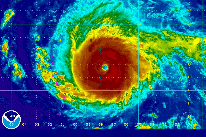
Banner Image: A Rainbow Infrared graphic of Hurricane Irma taken from 21:15 Coordinated Universal Time (UTC) on 4 September until 03:45 UTC 5 September from sensors on the GOES Floater satellite. Picture: Wikimedia
