Environment
A land of drought and flooding rains

A giant, continent-sized cloud that dumps rain from Broome to Hobart has increased in frequency over the past 33 years, but its impact may not be what you expect
Published 2 December 2019
On any given day in Australia, depending on where you are, you may look up – hoping for those rainclouds to appear in the sky, or wishing them away.
But what you may not realise, is the clouds you’re looking at could be part of a pretty amazing weather phenomena.

The Northwest Cloudband is a huge cloud that stretches from the East Indian Ocean to the southern coast of Australia and can cause widespread rainfall across the country.
It’s thousands of kilometres long, extending from tropical Australia to Tasmania.
Similar systems occur around the world and they go by different names: tropical intrusions, tropical-extratropical cloudbands and tropical plumes. But the names all imply the same idea – the tropics intruding on the higher latitudes and bringing with them a whole lot of water.
Our new study shows that winter extreme rainfall is four times more likely in Victoria during a Northwest Cloudband event and up to twelve times more likely in northwest Australia.
And these events are becoming more common.
The eastern Indian Ocean is the Northwest Cloudband nursery.
These giant clouds begin life as water evaporating from the warm surface of the Indian Ocean.
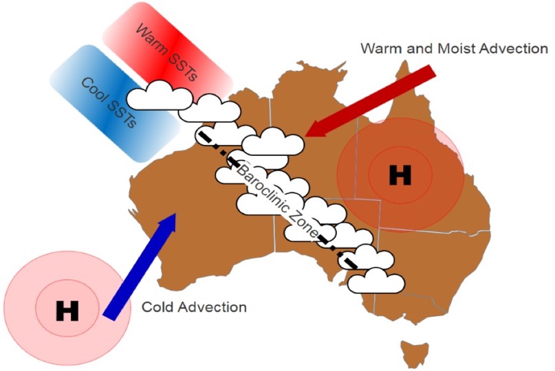
This evaporation is enhanced when the sea surface temperatures (SSTs) are warmer in the northeast Indian Ocean and cooler in the southeast Indian Ocean because this temperature difference makes the air above the ocean unstable.

The water vapour rises through the unstable atmosphere and forms clouds. But to get to southeastern Australia, without raining all the water out over the desert, the clouds need to hitch an express ride.
And this is where the extratropics come in.
The extratropics are typically defined as between 30 and 60 degrees latitude, and it’s in this zone that the weather is dominated by high and low-pressure systems.

Environment
A land of drought and flooding rains
In the Southern Hemisphere, air travels anti-clockwise around the centre of a high-pressure system and clockwise around a region of low-pressure.
Southern Australia is prone to these tropical visitors when there are high-pressure systems over southwest Western Australia and Queensland, as this sets up the ideal air flow for Northwest Cloudbands.
The southwestern high pushes cold air from the Southern Ocean towards northwest Australia, while the northeastern high pulls warm and wet air from the Coral Sea towards the centre of Australia.
When the warm northeasterly air meets the cold southwesterly air, they clash creating a huge zone of unstable rising air – perfect for cloud formation.

The moist air and cloud that began over the Indian Ocean then traverses our entire continent via this zone of instability.
Scientists were particularly interested in Northwest Cloudbands in the 1980s and 1990s.

The satellite era may have begun in the late 1970s with the launch of the first Geostationary satellites, but they were only just starting to be used to observe the weather – so scientists really only had access to a few years of useful data.
In these early studies, scientists manually identified Northwest Cloudbands by looking at grainy infrared satellite images of clouds over Australia.
But in the 21st Century, interest in the Northwest Cloudband waned.
In 2016, while researching the causes of Victorian changing rainfall with Professor Ian Simmonds and Dr Claire Vincent, we realised part of the puzzle was missing.
We knew Northwest Cloudbands caused rainfall in Victoria, but given we only had northwest cloudband records from the 80s and 90s, we couldn’t tell whether recent changes in Victorian rainfall had any relationship with Northwest Cloudbands.

The simple solution was to create our own updated record with the help of fellow School of Earth Sciences academic Dr Andrew King, the Department of Environment, Land, Water and Planning Victoria and the Australian Research Council Centre of Excellence for Climate Extremes.
The result was an algorithm that identifies Northwest Cloudbands over Australia from satellite observations of clouds.
Instead of manually searching approximately 14,000 images, the algorithm looks at the cloud over Australia from snapshots taken every three hours and tests the shape, location, continuity and size of the cloud to establish whether there is a Northwest Cloudband.

Sciences & Technology
Climate is warming faster now than last 2000 years
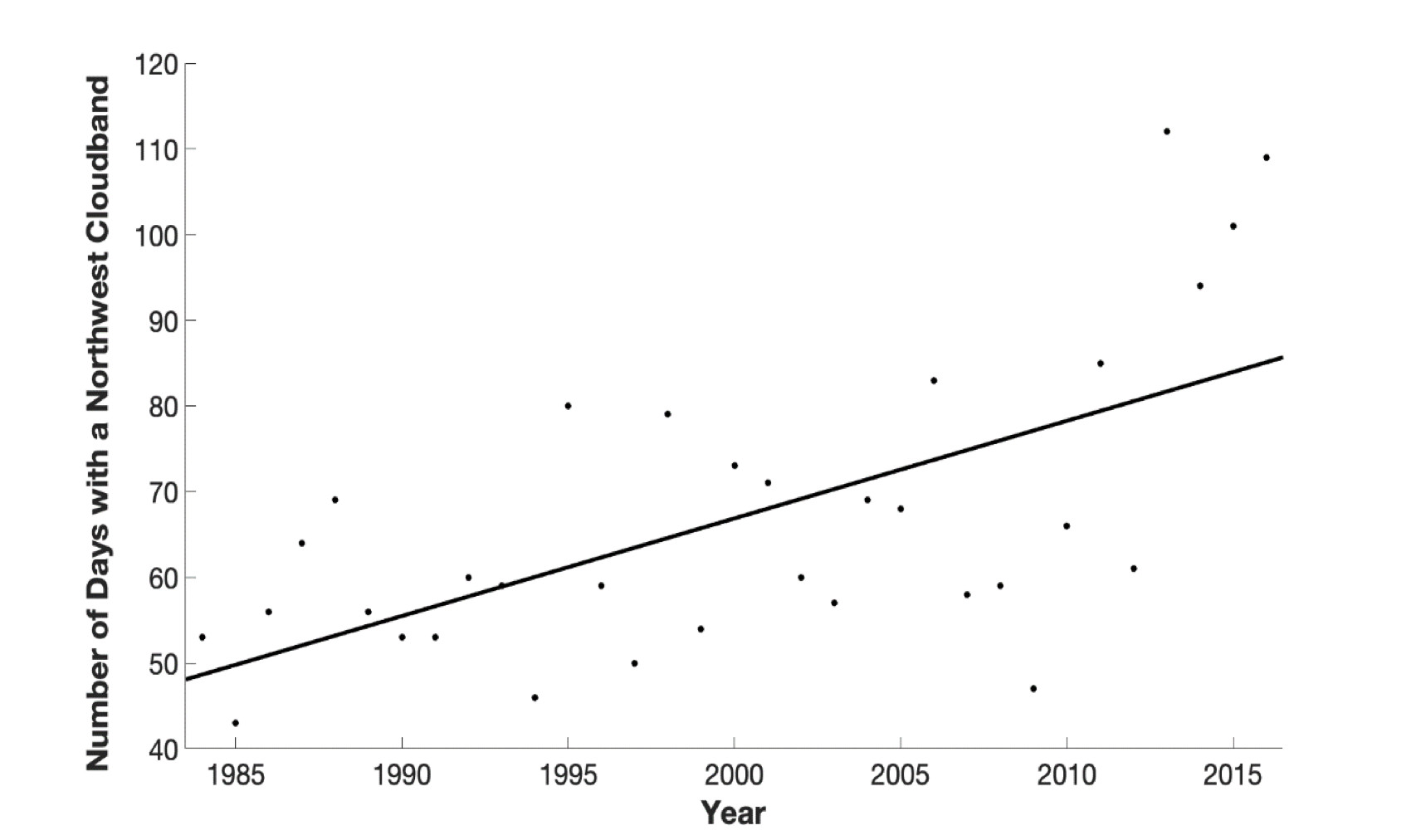
Our research produced a record of Northwest Cloudbands from 1984 through to 2016; the longest observational record of Australian Northwest Cloudbands. But it doesn’t stop there, as new satellite data becomes available, we are constantly updating the record.
Importantly, this 33-year-old record means we can now observe long-term trends. And we found Northwest Cloudbands are occurring more often over Australia at a rate of about one extra day per year.
In fact, they have nearly doubled in frequency and we don’t really know why.
There’s a raft of possible explanations all needing further research: climate change, the expansion of the tropical circulation system known as the Hadley Cell, aerosols and increased high-pressure systems in Southwest Western Australia.

Given the ongoing concern about the impact of drought in Australia, it would be nice to assume that an increase in the frequency of these cloudbands would bring more rain.
But in fact, the reverse may be true.

Environment
The global problem of thirsty cities
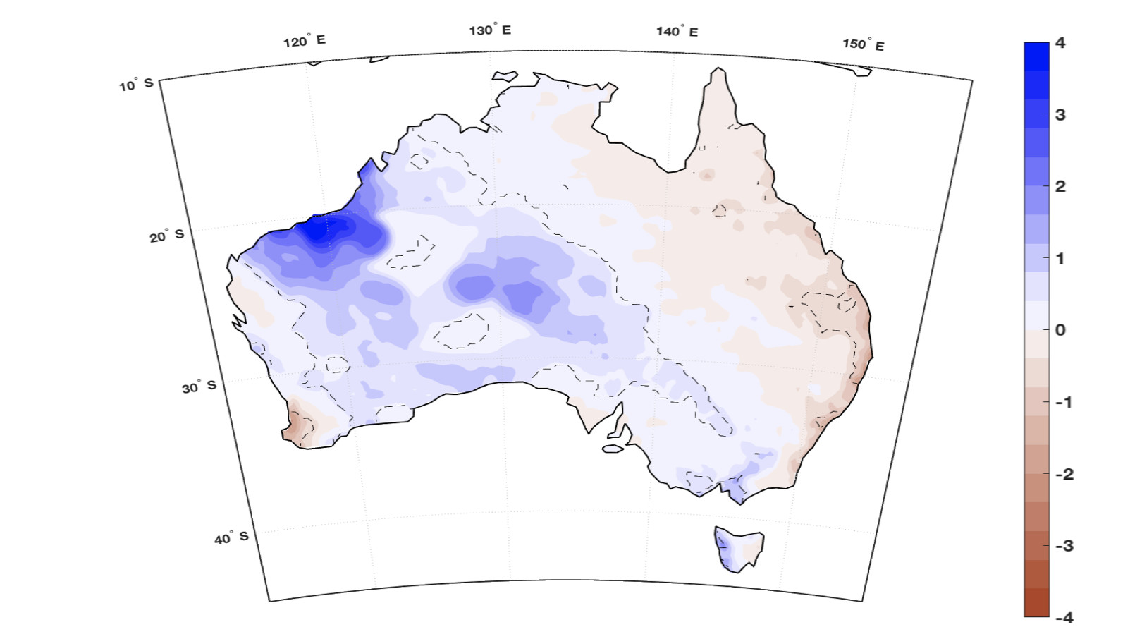
We found that while the Northwest Cloudband increases rainfall over northwest, central and southern Australia (blue regions in rainfall map), it’s actually associated with a daily rainfall deficit (brown regions in rainfall map) over eastern and southwestern Australia.
This means that, counterintuitively, more cloudbands could lead to less rainfall in certain parts of Australia.
In fact, we are now trying to understand whether the recent droughts in New South Wales and Queensland have any connection to years with above average Northwest Cloudbands.
We are starting to learn about the impacts of cloudbands, which is especially important for understanding Australia’s rainfall trends in the future climate.
Banner: Getty Images